We are in the Corvedale, an especially scenic location in the south of Shropshire. This is arguably the most scenic and rural area of the County and includes a large area - The Shropshire Hills - designated as of Outstanding Natural Beauty . It is ideal for country lovers, walkers, bird watchers and people who are interested in history. There is something for everyone, provided it is a tranquil, rural spot that you are seeking. Indeed, the Council for the Protection of Rural England found that the Shropshire Hills is one of only three tranquil areas in the whole country.
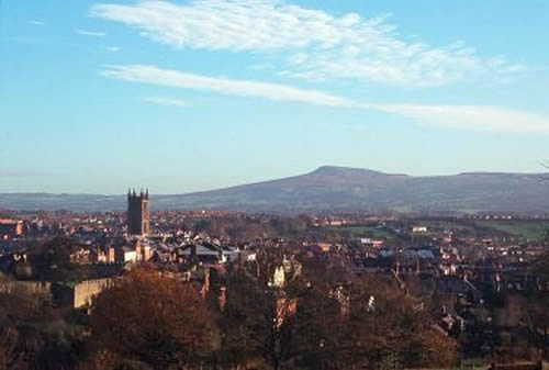
The FERNDALE FLAT is on the B4368, about a mile west of Shipton, at SO547905. Ordnance Survey maps label this location as Hopescross. We overlook the River Corve, towards the Brown Clee Hill, the highest spot in Shropshire. Walkers can leave the car at the Flat and follow the Shropshire Way and other local paths from the front door. Lovers of small and historic towns will enjoy visiting Bridgnorth, Ludlow, Much Wenlock and Church Stretton. A stroll in our own developing woodland leads to a viewpoint from which the Tudor manor house, Wilderhope, and views towards Wenlock Edge, can be seen.
Other advantages of this location include the lack of street lighting so the stars can be seen at night and the relative lack of noise and bustle so the birdsong can be heard in the daytime, songthrushes at twilight and owls in the later evening. Overhead, there are frequent visits by buzzards and the occasional sighting of red kites. Kingfishers and herons have also been seen alongside the nearby brook.
FERNDALE is easily accessible by car. Public transport is negligible so a car or cycles are essential, if only to make visits to hostelries for evening meals. Trains to Shrewsbury, Wales, Birmingham and other more distant places can be caught from Craven Arms and Telford. Each of these stations has a car park. Cycle hire (including electric bikes) is available in the area. We offer an electric vehicle charging point for the seriously ecological motorist.
If you prefer to travel to Shropshire by train, you could hire a car to reach the Flat and for local journeys.
In this case, you could arrange car hire with Enterprise Car Hire, who will meet your train at Telford or Shrewsbury Stations.
There are also plenty of regular taxis that you could hire.
Telford is a few stops from Wolverhampton or Birmingham New Street. Both stations have connections to the north and the south.
Phone 01952 200353 (Telford) or 01743 444777 (Shrewsbury) to make the arrangements. www.enterprise.co.uk
Another idea is to rent a car from the car-sharing club, Co-wheels.
These cars can be collected in Ludlow, a short walk from the station. See www.co-wheels.org.uk
Maps
- To check the location on your sat nav or mobile phone, the postcode TF13 6LB brings you to within half a mile. If your sat nav recognises Hopescross, this is a more exact location.
- Another place to see the location is on google maps
- OS Explorer Map 217 (2.5" to 1 mile) covers the area well
- OS Landranger Map 138 (1.25" to 1 mile) gives less detail but covers a larger area
- Maps and guides to local walks may be borrowed from the Flat
- Click here for a sketch map showing the Ferndale Flat
The Ferndale Flat is centrally located for:
Ludlow and the Titterstone Clee from Whitcliff
Ludlow - famed as one of England's finest small towns with its Norman castle and walls, mediaeval street pattern, market square (with events most weekends), timber framed houses and shops, two especially fine streets of Georgian houses, river walk and restaurants. The Tourist Information Centre and Museum are of interest and there is also a leisure centre with swimming pool on the outskirts. Festivals include the Food Fairs in June and September and the Arts Festival in the summer.
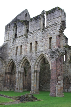
Wenlock Priory
Much Wenlock grew up around the Priory which is now an English Heritage property.
This very small town is unspoiled and has a museum and information centre, interesting shops and several places to eat.
The modern version of the Olympic Games began here.
Wenlock Edge - in the care of the National Trust: views, wildlife (including the recently returned red kite), walks. Part of the Shropshire Hills Area of Ooutstanding Natural Beauty.
Church Stretton - sits at the foot of the spectacular Shropshire Hills.
Much of this area is owned by the National Trust. The Long Mynd and Caer Caradoc appeal to serious walkers.
Others may prefer to drive up the Burway or the Cardingmill Valley and take more gentle walks from there,
to watch the gliding, paragliding and hang gliding or to enjoy the views. In Victorian times, Church Stretton was marketed as a spa town because of its mineral water supply.
The water, but not the spa, is still available. There is an award-winning tea shop and several good cafes and restaurants in the town plus an excellent deli and an independent bookshop.
Electric bikes may be hired here.
Places to eat
There are plenty to choose from in South Shropshire, ranging from pubs, country inns and cafes to award-winning restaurants, one of which has earned a Michelin star.
Four inns, serving food, are within a few miles of the Ferndale Flat.
See
Things to See and Do for more information on places to visit.